

By John Wiley
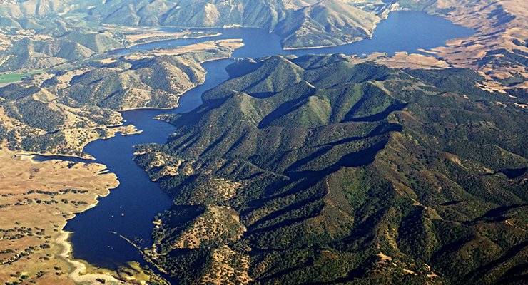
Recently while flying over the hills North of town we were startled to see this large expanse of water where we’d only seen dirt and sand for years. In fact, I’d forgotten that Twitchell Reservoir is there! The closer shot of the earthen dam and spillway evokes an impression of what it looked like a few weeks ago before the terrain went brown. (see above)
The long view toward the South from the other end is a bit hazy, but conveys some of the expanse it now covers.
The similar long view with map pin at the left, is a gMaps 3D sat view when it was comparatively puddle sized.
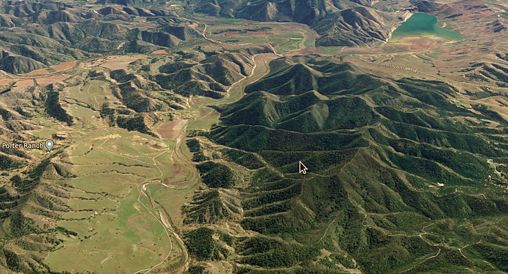


Quite a difference!
Yes! Actually startling, having flown directly over that area and near enough to see it many times in recent years.
Wow!
Love your stories and pics, John, good to see you here, as always.
Anyone know when the gMaps sat view was taken?
John, you can find data attributions used by Google Maps sat views by heading over to the web version of Google Earth. Data attributions appear at lower-left when you pass your cursor over the imagery. The oldest data in this SE view of Twitchell is 2/28/2021 – what a difference a few years makes!
https://earth.google.com/web/search/Porter+Ranch,+Santa+Maria,+CA/@35.05717882,
-120.35694972,339.59760471a,7363.78587244d,35y,145.79248754h,59.8941287t,-0r
/data=CigiJgokCXFTP4r3ikFAETxgNNJJd0FAGZ8J6wghEF7AIYqAZJwrHF7A
More on imagery attributions here:
https://support.google.com/earth/answer/6327779?hl=en&sjid=6258678298207427680-
NA#zippy=%2Csatellite-aerial-images
Ah, it says “2/8/21-newer” so maybe as I suspected, it’s composite of many sat images from different dates and even different satellites? If so maybe that water near the dam might have even been after the start of the rainy period?
A closeup sat view of the dam with shallow water dwindling to sand a bit over a mile has this 2023 attribution: https://goo.gl/maps/Agd1kzSCeAUxuPUg8
Wonder where that water in the sat view came from, because I recall seeing no water there at all during the drought. Maybe in Feb.’21 there had been a little rain. Anyway, thanks for the link and info E.B.
In my photo the water seems to go about 6.5 miles. I guess this will help raise the water table a little.
Zooming in on the reservoir, the data attribution stays at “2/28/21 – newer” which is Google’s way of saying 2/28/2021. Looks like there was water in Twitchell at the beginning of 2021 but it all went poof by the end of the year:
https://files.countyofsb.org/pwd/hydrology/Historic%20Data/Reservoirs/Twitchell%20Storage%202000%20to%20Present.pdf
I think your recollection is consistent with Google’s and the County’s data. Happy 4th!
Great photos! The only major California reservoir not reaching full capacity is Trinity Lake up in Northern California. The atmospheric river events focused on the center of the state, and they just missed the watershed for Trinity. A banner year for water in the state none.
No fishing/boating on Twitchell?
“No public access to the dam or reservoir,” sayeth Wiki. 🙁 Capacity is ~198k acre⋅ft capturing flow of the Cuyama & Sisquoc forming Santa Maria River. Twitchell (originally Vacquero) Dam was built by the Bureau of Reclamation in 1958. It’s for flood control, water, and recharging groundwater (~20k acre⋅ft/yr). Sedimentation is bad due to filling 70 percent faster than planned.
Minor correction, Twitchell doesn’t capture the Sisquoc river.
If I didn’t misunderstand the wiki, I hope you’ll correct it.
BadDawg, thanks for clarifying that the Cuyama & Sisquoc join forces to form Santa Maria River downstream of the dam near a bend in Foxen Cyn Rd. near Gary, here: https://goo.gl/maps/xrF6EqQdnVDW5emm9
Green to brown edges? I just noticed a slightly more green slope on the left side of the reservoir in the first pic, with a sharp transition to more brown near the left edge. It’s past the crest of the hill, so probably not from more humid air near the lake. Any guess why that might be? (btw, I tweaked the wiki wording to clarify river confluence, and added pix)
The photos are beautiful! Such a big difference between the flat surface of full lakes and the undulations of terrain that are exposed when the lakes are empty. Fascinating! Thank you.