

By John Wiley
On a 40 minute “Flower Fly” from Santa Barbara you can see snowy peaks and more. Before takeoff, this practicing perky heavy hauler passed by. Did you see one like it showing off its superpowers at the Pt. Mugu Airshow?
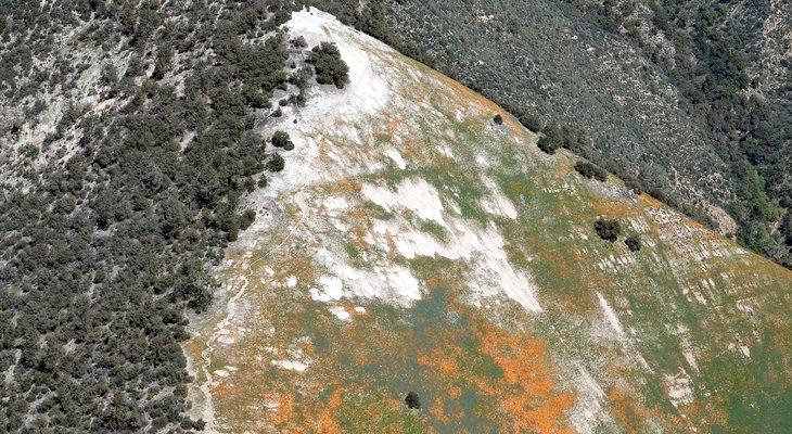
Out beyond the Santa Ynez river was a first glimpse of scattered poppy fields. Can you tell that’s snow on the distant peaks? Aren’t the sheer cliffs at bottom-right magnificent?
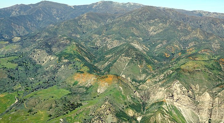
Poppy Peaks & Snowy Peaks
Surely some of the cars on that road are Edhat readers getting an up close look at this year’s variety of species. From above, it refreshed memories of flying this area with fun flyer Jo Duffy and seeing dense stands of yellow and purple varieties (maybe we’ll see some in coming weeks). Can you make out all ten of the cars in this low-res pic?
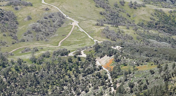
Different kind of Rush hour
Taking a turn over Zaca Lake, it looked like there may be a new dock and in the full size zoom pic, I can see a work truck. Anyone know if they’re going to open this year?
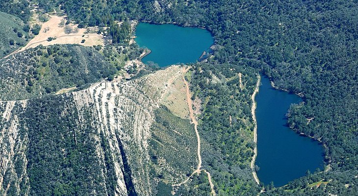
Zaca Shapes Up
Crossing mountains back over toward the South, this unusual site came into view. Can you recognize it from this perspective? Have you been there?
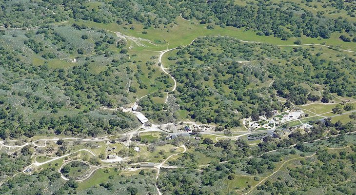
Personal Paradise
This pyramid peak is always fun during wildflower season. Is that a person just below the peak toward the far edge of the clear area?
Grass Mountain
Zoomed in, can you get an impression of individual blossoms even in this low res version? Will those bluish green areas bloom too?
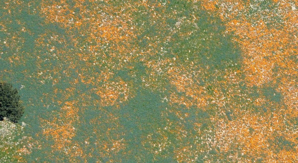
Zoom view
Have you seen the thrilling Cachuma spillway lately? Nestled among the newly green terrain, the whole lake is a shimmering gem.
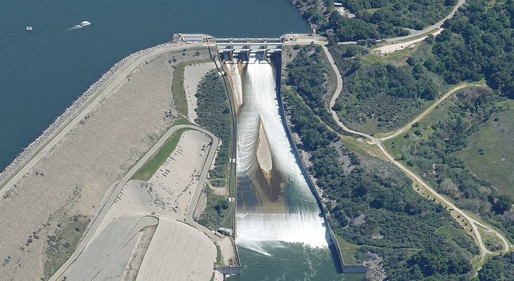
Bradbury Mist
The campground looks quite different from a few months ago! Are the campsites all full? Even on this Thursday mid-afternoon flight, the boat ramp was busy. Have you been out on the water, or watched from shore? Can you “see” the outline of Snoopy crouching to spring, in the peninsula outline?
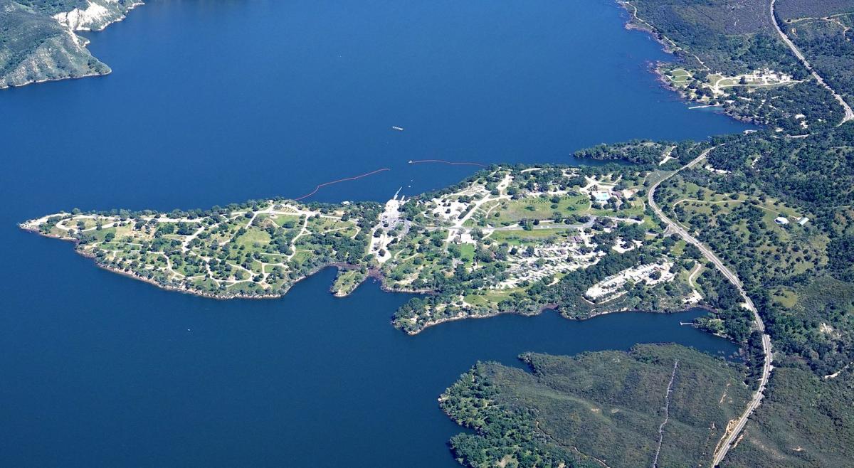
Cachuma Spring


How many of the ten cars have you been able to count? Anyone tagged more than 7? Knowing where they are from the full-res original, eight is fairly easy. The 9th takes more study on this low-res version, and the 10th is pretty tough. I’m a bit surprised no sharp-eyed Edhatters have claimed any at all yet. Maybe worn out from March Edness?
I love the shapes and patterns in the flowering hills and the abundance of full lakes and dams! The overview perspective of both are amazing! Thanks so much for sharing these with us.
The Poppies – really do Pop out in the aerial views 🙂 – it makes me wonder Why those particular spots are chosen for the spectacular color especially amid all the similar surroundings?
U.S. roundels (that star in a circle, optionally bracketed with stripes attached to the sides) on military aircraft have mostly reduced contrast to make them harder for enemies to spot. So in my pix of “984” taking off only those 3 numbers on the nose are easily readable. Ever curious, today I messed with the bright sunlit high-contrast image and at extreme levels I could barely make out “08 7984” on the tail (vertical stabilizer). Alas, only one hit with google: a 4/8/18 FlightAware photo of “16-7984” landing at Shannon. Luckily though, that was a low-contrast day and on the tail it’s easy to read “QB 7984” and googling that found an entry on AirHistory.net saying it’s a USMC KC-130J (aerial refueling tanker and tactical airlifter) stationed at Miramar. Incidentally, although C-130s may seem slow and cumbersome, that FlightAware page says 984 flew from SB to Lk. Havasu in an hour. That’s 300 miles in a straight line (they flew a “dogleg” route), and they cruised leisurely along at 375mph. Maybe riding a tailwind, or the latest engines and propellers on the J model have increased the speed up at 21,000′ where they flew. Rather impressive for an aircraft designed in 1954 would you say?
I see 4 cars just up the road from the poppies, 3 in the turnout area below and 3 down lower on the road, but am possibly wrong on the 3rd car down by the turnout because of the trees.
I like the photo where you think you see the person just below the peak
Edney, your attention to detail is impressive to me! In such low resolution, it’s hard for me to count the cars even with the full res pic to reference. So, at the bottom of the pic, there’s a tree blocking the road view. Next above that there’s a tree shadow followed by the tree left of the road making that shade, another tree on the left, a thin shadow on the road and a small shadow on the right shoulder. Next is a small white pickup or car, then another white vehicle partially obscured by a long branch of the tall tree on the right shoulder followed closely by another branch, then another white vehicle near the middle of the poppy slope. What helps me spot them is that they’re evenly spaced, as if two white suv/vans are following a lead pickup/car. Trickiest of all comes next, at the far end of the poppy slope – in the shade of the tree at the left is a light color vehicle followed very closely by a dark one, possibly both parked at a slightly wider part of the road. It’s easier to make out a pickup at the gated turnoff to the right and another left of the curve. A dark car just beyond the trees, another parked at the junction, and a pickup nearing the top-left end of the road. That’s 3 at the bottom, 2 obscured in the shade, 2 at the bend, and 3 more beyond. Kudos on tagging 7 amid the camouflage!
I love the spillway shot of Bradbury Dam. Growing up next to Shasta Dam, it’s a rare sight when water spills over the spillway. Shasta has only ~20’ to go hit the spillway.
We were looking at a wiki list of CA reservoirs, and to our surprise it seemed that Shasta is the biggest by volume. Maybe partly due to all the branches we only see from the air and presumably you by boat, with many deep areas in canyons between the mountains?
Excellent!
Thanks 🙂 – Which is your favorite, Shasta?
Thanks John for the great set of pics! Have you ever flown over the Carrizo Plain National Monument?…would be wonderful to see while it’s in full bloom!
Aqua, I’m glad you’re sending Ed pix because yes we’ve seen a bloom in the Plain and also in Cuyama where the colors were so dense and bright we assumed they were large blossoms. When we then landed at Cuyama airport it was quite a surprise to discover the flowers were tiny!
I can recognize Neverland Ranch. Just below Grass Mountain (Pyramid Peak)where the poppy’s are blooming. Was there several times in the 90’s
It was even more unusual from the air when the rides were still there! I don’t think we ever saw the train running, but maybe you got a ride on it?
No train ride. Suppling building materials
Today I drove the 46/41 from Paso Robles to kettleman city. The flowers on the 41 were enthralling. Orange, 2 different yellows, purple.
I’ll submit some quick iPhone photos to edhat.
Go SBT! While working my way back up the latest Comments here I’d mistaken your promise of sending bloom pix to Ed, with Aqua’s mention of the flowers. I hope lots of people will, and if we manage to fly out to CA Valley during the bloom I’ll send some too.
Shasta Lake is California’s largest reservoir with a capacity of 4,550,000 acre-feet. The storms have replenished the lake, with it filling by 2,500,000 acre feet since January, and it just broke 4,000,000 af this week. This will be the second time in my life time that the lake went from severely depleted to full in a single season. The last time was the 1976-1977 drought which was much worse than the current one that just ended. Back then the lake was down 220’, almost shutting off the penstocks to the power house.
Back then an atmospheric river event hit the state in May, causing huge snowmelt on Mount Shasta sending an enormous amount of water to the lake. They had to open up all the flood gates to avert over topping. I believe they were letting out 100,000cfs. It was an incredible sight.
If the same thing repeats this year and hits the heavy Sierra snow pack it will be a little too exciting for the Central Valley. It’s just normal cycles in long term California weather.
Had to throw in the bit of BS at the end, eh?
Oh, it’s just normal record-breaking weather!