

Electricity is something we normally discuss the monthly bills, fires, or service disruptions. The majority of the time, it is our silent servant.
However, if you have wondered about how and when electricity was introduced to Santa Barbara, here’s a snapshot of one day in electricity’s long history in town.
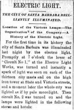
On the evening of March 15, 1887, 137 years ago, after much work and privately funded expense, very bright carbon arc lights were lit on tall masts primarily on State Street, with the coal fueled power plant located on the corner of Ortega and Santa Barbara Streets. It was an event that enhanced Santa Barbara forever.


Fun to imagine how exciting that was for the many who welcomed this giant leap into the future – and how terrifying for those swayed by rumors of associated dangers. Thanks for sharing your research, Joe. Arc light is so harsh, loud, hot and brilliant it would’ve been impossible to ignore. Is that a lone light on Milpas at Haley? I guess the bold line that zig zags across town is the rail line, now Gutierrez? Speaking of zig zag, did anyone else see the item about how two-word colloquialisms always start with an “i” vowel word (ping pong, clippety clop, pitter patter, etc…)?
Hello John, and THANK YOU for your comment! I too was surprised that Haley/Milpas had a light, however that’s what the newspaper article reported. YES, the bold zig/zag is the original route of the S.P. that ran on Gutierrez, that Potter had the S,P, change the route to be close to his new hotel.
The station that was closest to the Potter at the time was on Victoria St. which also had a streetcar running to it, which undoubtedly helped the Arlington Hotel….which was the competition!
One aspect of the Potter I have yet to read about was due to close proximity of the very busy railroad behind it, I’m sure that there was DEFINITELY a noise component to staying there, since train traffic was considerably more then than it is now! Cheers!
Micheltorena/SB St. light had me curious until figuring out that’s the intersection, then the obvious reason for a light at that lower-traffic intersection. The other two off State on Carrillo highlight (no pun intended) that area’s long been the “heart” of SB. Your map also points out how much Mission Creek has been diverted to parallel the NE side of 101 (or whatever street was there by the SPRR in 1887). Must’ve been a mess in floods, with 3 bridges and a winding path. Interesting how the Arlington v. Potter struggle affected city development, and your point about how the latter must’ve rattled and rocked with every passing freight.