

To allow for 4,142 new residential units to be created in unincorporated South Santa Barbara County by 2031, Santa Barbara County Supervisors are voting on rezoning 16 individual parcels in 11 locations in unincorporated this Friday, May 3.
The meeting starts at 9 a.m. at the Board of Supervisors Hearing Room at 105 E. Anapamu, Santa Barbara (entrance on Anacapa St.). The meeting is also livestreamed and the agenda is available on the May 3 meeting details page.
The public is welcome to comment at the meeting’s public hearing, and the Office of the Clerk of the Board accepts and distributes written comments right up to the moment the item is being heard. Submit comments by email to sbcob@countyofsb.org.
The vote on rezoning parcels to allow dense residential development is part of the Housing Element 2023-2031 process to meet Regional Housing Needs Assessment numbers that have been assigned to unincorporated South Santa Barbara County by the Santa Barbara County Association of Governments (SBCAG).
These rezones (also called upzones because they would allow more residential units) are just part of the county’s plan to meet the numbers. The County Supervisors also have county-owned land to consider for residential development and pending residential development already in the pipeline (look for future articles on these topics).
A summary of the 11 locations for rezoning in unincorporated South Santa Barbara County
For the South Coast, the Santa Barbara County Planning Commission determined at an April 1 meeting to recommend that the Board of Supervisors rezone 16 of the 18 potential parcels considered for rezoning, which I grouped here into 11 areas, based on location and property owner:
- St. Athanasius Orthodox Church parcel (east of Goleta)
- Scott parcel at 5381 Ekwill St. (east of Goleta)
- Four parcels near Por La Mar Nursery on South Patterson Ave. (east of Goleta)
- Two San Marcos Growers parcels on Hollister and S. San Marcos Rd. (east of Goleta)
- Montessori Center School parcel at 5050 Hollister Ave. (east of Goleta)
- Two St. Vincent’s parcels near Cathedral Oaks Rd./Foothill Rd. (east of Goleta)
- Tatum parcel at 4750 Hollister Ave. (east of Goleta)
- Glen Annie Golf Course parcels at 7380 Cathedral Oaks Rd. (north/west of Goleta)
- Friendship Manor parcel east of 6647 El Colegio Rd. (Isla Vista)
- Hope Church parcel at 560 N. La Cumbre Rd. (between 154 and Santa Barbara)
- Two Van Wingerden parcels (near Carpinteria)
The Planning Commission described its guidance to the County Board of Supervisors in a Board Letter (document 1) on the Planning Item/Public Hearing page 24-00397 for the May 3 meeting. The presentation from Santa Barbara Planning Department staff is document 77.
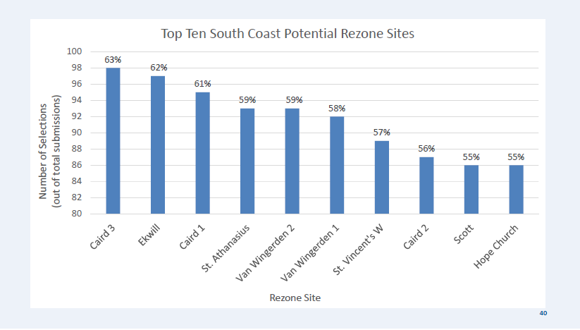
The County has encouraged residents to participate by looking at potential housing sites to meet numbers in the South Coast Balancing Act online tool. The staff presentation for Friday’s meeting also includes a chart with most popular sites for rezoning based on public feedback.
Let’s look at what has been proposed by the property owners and has made it through the process with the County Planning Commission.
To select the best parcels for rezoning, the County Supervisors are using factors including: the number of homes for low-, moderate-, and upper moderate-income households based on area median income; partnerships with nonprofits or the county housing authority; partnerships with local employers; conformity to community plan; travel corridor and mixed use; and opportunities for rentals and homeownership.
The facts for each parcel include the current development potential before rezoning, the proposed new zoning, and how many residential units are projected to be added. By the time each individual parcel goes through the planning process, these numbers might change.
St. Athanasius Orthodox Church parcel (east of Goleta)
- Assessor’s Parcel Number: 071-140-072
- Google Maps link: 300 Sumida Gardens Lane
- Current development potential before rezoning: The 20.56 acre parcel is currently zoned as AG-I-10 Inland Urban Area and is currently used for the church rectory and agriculture crops. Airport Zone 2 covers approximately 3 acres, so no units were assigned to that portion of the site. With current AG-I-10 zoning, one-family residential use is the default, but accessory dwelling units (ADUs) are allowed, and property owners can apply for permits for farm worker employee housing.
- Proposed new zoning: DR-30/40 (Min/Max), which means a minimum of 30 per acre and a max of 40 per acre of residential units. Only a subset of the total parcel is considered for residential development. The maximum number of residential units would be 300.
- Projected affordability with new zoning: 150 of the total 300 new residential units are expected to be affordable for low-income households (below 80% area median income) and 75 are expected to be affordable for moderate-income households (80% to 120% area median income).
Scott parcel at 5381 Ekwill Street (east of Goleta)
- Assessor’s Parcel Number: 071-140-071
- Google Maps link: 5381 Ekwill Street
- Current development potential before rezoning: The 9.36 acre landscape materials yard is currently zoned as AG-I-10 Inland Urban Area but it is not currently used for agriculture. With current AG-I-10 zoning, one-family residential use is the default, but accessory dwelling units (ADUs) are allowed, and property owners can apply for permits for farm worker employee housing.
- Proposed new zoning: DR-30/40 (Min/Max), which means a minimum of 30 per acre and a max of 40 per acre of residential units. The maximum number of residential units was shown on the South Coast Potential Rezone Sites table as 246.
- Projected affordability with new zoning: 125 of the total 246 new residential units are expected to be affordable for moderate-income households (80% to 120% of area median income).
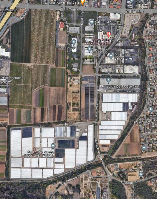
Four parcels near Por La Mar Nursery on South Patterson Ave (east of Goleta)
Four parcels are combined around Por La Mar Nursery, north of Hollister Ave on South Patterson Ave. The Caird family started the Por La Mar Nursery in 1972. The developers have said potential partners for the project are People’s Self Help Housing for low-income affordable housing and the South Coast Chamber of Commerce housing consortium to allow businesses to sponsor, reserve, or subsidize housing for their employees.
Parcel to the east of 5381 Ekwill Street
- Assessor’s Parcel Number: 071-140-048
- Google Maps link: To the east of 5381 Ekwill Street
- Current development potential before rezoning: The 8.23 acre parcel currently zoned as AG-I-10 Inland Urban Area and is currently used for crops. With current AG-I-10 zoning, one-family residential use is the default, but accessory dwelling units (ADUs) are allowed, and property owners can apply for permits for farm worker employee housing.
- Proposed new zoning: DR-30/40 (Min/Max), which means a minimum of 30 per acre and a max of 40 per acre of residential units. The maximum number of residential units was shown on the South Coast Potential Rezone Sites table as 218.
- Projected affordability with new zoning: 50 of the total 218 new residential units are expected to be affordable for moderate-income households (80% to 120% of area median income).
Caird parcel #1 at 600 S. Patterson
- Assessor’s Parcel Number: 065-090-031
- Google Maps links: 600 South Patterson
- Current development potential before rezoning: The 15.22 acre parcel is currently zoned as AG-I-10 Inland Urban Area and is currently used for a nursery and greenhouses. With current AG-I-10 zoning, one-family residential use is the default, but accessory dwelling units (ADUs) are allowed, and property owners can apply for permits for farm worker employee housing.
- Proposed new zoning: DR-20/25 (Min/Max), which means a minimum of 20 per acre and a max of 25 per acre of residential units. The maximum number of residential units was shown on the South Coast Potential Rezone Sites table as 192.
- Projected affordability with new zoning: All of the new residential units on this site are expected to be affordable for low-income households (below 80% area median income)
Caird parcel #2 at 620 S. Patterson
- Assessor’s Parcel Number: 065-230-012
- Google Maps links: 620 South Patterson
- Current development potential before rezoning: The 15.85 acre parcel is currently zoned as AG-I-10 Inland Urban Area and is currently used for a nursery and greenhouses. With current AG-I-10 zoning, one-family residential use is the default, but accessory dwelling units (ADUs) are allowed, and property owners can apply for permits for farm worker employee housing.
- Proposed new zoning: DR-20/25 (Min/Max), which means a minimum of 20 per acre and a max of 25 per acre of residential units. The maximum number of residential units was shown on the South Coast Potential Rezone Sites table as 76.
- Projected affordability with new zoning: All of the new residential units on this site are expected to affordable to “above moderate income” which means above 120% of area median income.
Caird parcel #3 at 905 S. Patterson 4960 Hollister Ave
- Assessor’s Parcel Number: 071-190-036
- Google Maps links: 905 S. Patterson
- Current development potential before rezoning: The 60.83 acre parcel is currently zoned as AG-I-10 Inland Urban Area and is currently used for a nursery and greenhouses. With current AG-I-10 zoning, one-family residential use is the default, but ADUs are allowed, and property owners can apply for permits for farm worker employee housing.
- Proposed new zoning: DR-20/25 (Min/Max), which means a minimum of 20 per acre and a max of 25 per acre of residential units. The maximum number of residential units was shown on the South Coast Potential Rezone Sites table as 390.
- Projected affordability with new zoning: All of the new residential units on this site are expected to affordable to “above moderate income” which means above 120% of area median income.
Two San Marcos Growers parcels on Hollister and S. San Marcos Rd. (east of Goleta)
The Hodges family started San Marcos Growers in 1979 and began operating it as a wholesale nursery. The property was originally zoned as residential and was zoned as agricultural in 1993. Parcel #2 is expected to be managed by the Housing Authority of the County of Santa Barbara.
This development was a pending project already in the works. Originally the application to develop this land was filed through the Builder’s Remedy in the window before the County’s Housing Element was approved by the California Department of Housing and Community Development. The partnership to develop this land now includes Presidio Capital Partners, the Hodges Family, Fuller Apartment Homes, and the Housing Authority. The developers have said they are also working with the South Coast Chamber of Commerce housing consortium to allow businesses to sponsor, reserve, or subsidize housing for their employees.
San Marcos Growers parcel #1 at 4960 Hollister Ave
- Assessor’s Parcel Number: 065-040-041
- Google Maps link: 4960 Hollister Ave
- Current development potential before rezoning: The 27.37 acre parcel is currently zoned as AG-I-5 Inland Urban Area and is currently used for a nursery and crops. With current AG-I zoning, one-family residential use is the default, but accessory dwelling units (ADUs) are allowed, and property owners can apply for permits for farm worker employee housing.
- Proposed new zoning: DR-30/40 (Min/Max), which means a minimum of 30 per acre and a max of 40 per acre of residential units. The maximum number of residential units was shown on the South Coast Potential Rezone Sites table as 746.
- Projected affordability with new zoning: About 50 of the total 746 new residential units are expected to be affordable for moderate-income households (80% to 120% of area median income).
San Marcos Growers parcel #2 at 4960 Hollister Ave
- Assessor’s Parcel Number: 065-030-012
- Google Maps link: 125 S. San Marcos
- Current development potential before rezoning: The 5.7 acre parcel is currently zoned as AG-I-5 Inland Urban Area and is currently used for a nursery and crops. With current AG-I zoning, one-family residential use is the default, but ADUs are allowed, and property owners can apply for permits for farm worker employee housing.
- Proposed new zoning: DR-30/40 (Min/Max), which means a minimum of 30 per acre and a max of 40 per acre of residential units. The maximum number of residential units was shown on the South Coast Potential Rezone Sites table as 250.
- Projected affordability with new zoning: All of the new residential units on this site are expected to be affordable for low-income households (below 80% area median income)
Montessori Center School parcel at 5050 Hollister (east of Goleta)
A development partnership of Rethink Development and Montessori Center School, originally the application to develop this land was filed through the Builder’s Remedy in the window before the County’s Housing Element was approved by the California Department of Housing and Community Development. The developers have said they will withdraw an application under Builder’s Remedy process if the parcel is rezoned.
- Assessor’s Parcel Numbers: 065-080-024, 065-080-008, 065-080-009
- Google Maps links: 5050 Hollister Ave.
- Current development potential before rezoning: The 11.4 acres include an abandoned dwelling and are currently zoned AG-I-5 Inland Urban Area. With current AG-I zoning, one-family residential use is the default, but accessory dwelling units (ADUs) are allowed, and property owners can apply for permits for farm worker employee housing.
- Proposed new zoning: Split into three parts: 5.3 acres at DR-30/40 (Min/Max), which means a minimum of 30 per acre and a max of 40 per acre of residential units, DR-12.3 for 3.1 acres, and REC for 3 acres. The maximum number of residential units was shown on the South Coast Potential Rezone Sites table as 196 total.
- Projected affordability with new zoning: 20 of the total 196 new residential units are expected to be affordable for low-income households (below 80% area median income) and 20 are expected to be affordable for moderate-income households (80% to 120% area median income).
Two St. Vincent’s parcels near Cathedral Oaks Rd./Foothill Rd. (east of Goleta)
St. Vincent’s, a nonprofit that started in the Santa Barbara area in 1858, owns two vacant parcels that it wants to use for affordable housing for low-income households.
St. Vincent’s eastern parcel, 400 ft. North of the Hwy 154 & Cathedral Oaks
- Assessor’s Parcel Number: 059-130-011
- Google Maps links: East of 4150 Foothill Rd.
- Current development potential before rezoning: The 15.69 acre parcel currently zoned as DR-1 Inland Urban Area and DR-4.6 Inland Urban Area is vacant. With current zoning, DR-1 and DR-4.6 allow 1 residential units per acre and 4.6 residential units per acre.
- Proposed new zoning: DR-20/30 (Min/Max), which means a minimum of 20 per acre and a max of 30 per acre of residential units. The total number of residential units was shown on the South Coast Potential Rezone Sites table as 75.
- Projected affordability with new zoning: All of the new residential units on this site are expected to be affordable for low-income households (below 80% area median income)
St. Vincent’s western parcels at 4150 Foothill Rd
- Assessor’s Parcel Number: 059-130-014 and 059-130-015
- Google Maps links: 4150 Foothill Rd.
- Current development potential before rezoning: The land that St. Vincent’s owns at 4150 Foothill Road is currently zoned as DR-1 Inland Urban Area is vacant. It is broken up into two parts: one that is 4.61 acres and one that is 28.76 acres. With current zoning, DR-1 allows 1 residential unit per acre.
- Proposed new zoning: DR-20/30 (Min/Max), which means a minimum of 20 per acre and a max of 30 per acre of residential units. The total number of residential units was shown on the South Coast Potential Rezone Sites table as 100.
- Projected affordability with new zoning: All of the new residential units on this site are expected to be affordable for low-income households (below 80% area median income)
Tatum parcel at 4750 Hollister Ave. (east of Goleta)
Tatum is a pending project that was already in the works that the Planning Commission recommended for rezoning to increase density from its current 20 residential units per acre. Originally the application to develop this vacant land between El Camino School and Turnpike Shopping Center was filed through the Builder’s Remedy in the window before the County’s Housing Element was approved by the California Department of Housing and Community Development. This former school district property proposal is a collaboration between Red Tail Multifamily Land Development, LLC and the Housing Authority.
- Assessor’s Parcel Number: 065-040-026
- Google Maps links: Tatum Property 4750 Hollister Ave.
- Current development potential before rezoning: The 23-acre parcel is currently zoned as DR-20 and 10-E-1 and is vacant. A maximum of 20 residential units per acre can be built on DR-20 zoned land without rezoning.
- Proposed new zoning: DR-20/30 (Min/Max), which means a minimum of 20 per acre and a maximum of 30 per acre of residential units. The total number of residential units was shown on the South Coast Potential Rezone Sites table as 545.
- Projected affordability with new zoning: About 100 of the 545 new residential units on this site are expected to be affordable for low-income households (below 80% area median income)
Glen Annie Golf Course parcels at 7380 Cathedral Oaks Rd. (north/west of Goleta)
The owners of the Glen Annie Golf Course, Touchstone Golf or JTGV LLC, have partnered with Flowers & Associates for a proposal for 1,000 residential units, and have said they are planning to donate 7.7 acres of land to a nonprofit for development of low-income and moderate income residential housing. Potential partners for that parcel have included the Santa Barbara Unified School District for employee housing, Habitat for Humanity of Southern Santa Barbara County, and the Housing Authority of the County of Santa Barbara.
- Assessor’s Parcel Numbers: 077-530-021, 077-530-020, 077-530-012
- Google Maps link: 7380 Cathedral Oaks Rd
- Current development potential before rezoning: Split into three parts: 76.52, 7.82, and 10.36 acres, currently zoned as AG-II-40 Inland Rural Area and used as a golf course. AG-II zones allow single family dwelling unit per legal lot, including a mobile home, one accessory dwelling unit or one junior accessory dwelling unit per legal lot, and one guest house or artist studio per legal lot, greenhouses, on-shore oil development, excavation or quarrying of building or construction materials, special care homes, transitional and supportive housing, agricultural employee dwellings, and cannabis cultivation and nursery, distribution, and non-volatile manufacturing.
- Proposed new zoning: DR-5 and DR-20/30 (Min/Max). The maximum number of residential units was shown on the South Coast Potential Rezone Sites table as 1,000.
- Projected affordability with new zoning: About 210 of the total 1,000 new residential units are expected to be affordable for low-income households (below 80% area median income) and 108 are expected to be affordable for moderate-income households (80% to 120% area median income).
Friendship Manor parcel east of 6647 El Colegio Rd (Isla Vista)
- Assessor’s Parcel Number: 075-020-035
- Google Maps links: Vacant lot east of 6647 El Colegio Rd.
- Current development potential before rezoning: This 1.2 acre vacant lot next to the Friendship Manor senior housing is currently zoned as High Density Student Residential (SR-H-20) Coastal Urban Area. With current zoning, a total of 20 residential units per acre could be built, which would be 24.
- Proposed new zoning: DR-30/40 (Min/Max), which means a minimum of 30 per acre and a maximum of 40 per acre of residential units. The total number of residential units was shown on the South Coast Potential Rezone Sites table as 36.
- Projected affordability with new zoning: About 18 of the total 36 new residential units are expected to be affordable for low-income households (below 80% area median income) and 9 are expected to be affordable for moderate-income households (80% to 120% area median income).
Hope Church parcel at 560 N. La Cumbre Rd. (between 154 and Santa Barbara)
- Assessor’s Parcel Number: 057-143-001
- Google Maps link: 560 N. La Cumbre Rd.
- Current development potential before rezoning: This 2.95-acre parcel is currently zoned as 8-R-1 Inland Urban Area and is used for a church building and rectory. This is a single family residential zone, but accessory dwelling units (ADUs) can be built on single-family home lots.
- Proposed new zoning: DR-20/30 (Min/Max), which means a minimum of 20 per acre and a maximum of 30 per acre of residential units. The total number of residential units was shown on the South Coast Potential Rezone Sites table as 50.
- Projected affordability with new zoning: About 25 of the total 50 new residential units are expected to be affordable for low-income households (below 80% area median income) and about 13 are expected to be affordable for moderate-income households (80% to 120% area median income).
Two Van Wingerden parcels (near Carpinteria)
Van Wingerden parcel #1 at 4098 Via Real
- Assessor’s Parcel Number: 004-013-023
- Google Maps links: 4098 Via Real
- Current development potential before rezoning: This parcel is currently zoned as AG-I-5 Coastal Rural Area and used for a nursery and greenhouses. With current AG-I zoning, one-family residential use is the default, but accessory dwelling units (ADUs) are allowed, and property owners can apply for permits for farm worker employee housing.
- Proposed new zoning: DR-20/30 (Min/Max), which means a minimum of 20 per acre and a maximum of 30 per acre of residential units. The total number of residential units was shown on the South Coast Potential Rezone Sites table as 236.
- Projected affordability with new zoning: About 118 of the total 236 new residential units are expected to be affordable for low-income households (below 80% area median income) and about 59 are expected to be affordable for moderate-income households (80% to 120% area median income).
Van Wingerden parcel #2 at 4711 Foothill Rd
- Assessor’s Parcel Number: 004-005-001
- Google Maps links: 4711 Foothill Rd.
- Current development potential before rezoning: This parcel is currently zoned as AG-I-10 Coastal Rural Area and used for a nursery and greenhouses. With current AG-I-10 zoning, one-family residential use is the default, but accessory dwelling units (ADUs) are allowed, and property owners can apply for permits for farm worker employee housing.
- Proposed new zoning: DR-20/30 (Min/Max), which means a minimum of 20 per acre and a maximum of 30 per acre of residential units. The total number of residential units was shown on the South Coast Potential Rezone Sites table as 180.
- Projected affordability with new zoning: About 90 of the total 180 new residential units are expected to be affordable for low-income households (below 80% area median income) and about 45 are expected to be affordable for moderate-income households (80% to 120% area median income).
Other parcels under consideration for rezoning
Giorgi family parcel at Hollister Ave. and Ward Memorial Dr. (near Goleta city limits)
Although not selected by the Planning Commission, the Giorgi family parcel at Hollister Ave. & Ward Memorial Drive is also expected to be considered. The 64.8 acres, currently zoned AG-I-10 Inland Urban Area and used for orchard and crops. With a rezone to DR-30/40 (Min/Max), the property owners could build 1,177 units, including 300 affordable to low-income households, 120 affordable to moderate-income households (with incomes at 120% of the area median income), and 60 affordable to upper moderate-income households (those who earn 200% of the area median income). The property owners and developers are partnering with Related, a national developer of affordable housing.
The proposal previously presented includes 6-acre public park, and space for a childcare facility and other commercial uses for the surrounding community. This site, if considered for rezoning with the other other parcels near South Patterson, could allow the County Supervisors to consider how all sites might work together to coordinate traffic circulation, trail connections. The property owners/developers are also potentially participating with the South Coast Chamber of Commerce Employer Housing Consortium and potentially considering a local preference program.
Like the San Marcos Growers, Tatum, and Montessori Center School properties, the Giorgi parcel is a pending project already in the works, even without the rezone. Originally the application to develop this land was filed through the Builder’s Remedy in the window before the County’s Housing Element was approved by the California Department of Housing and Community Development.
County-owned parcels in south county
Handled in a separate discussion, the County Supervisors also have county-owned land to consider for residential development to meet its share of the Regional Housing Needs Assessment numbers for South County. The staff presentation for the May 3 meeting includes the following list:
- Flag Lot
- Probation Building
- Juvenile Hall
- Page and Fire
- Food Bank
- Hollister Lofts
- Child Family Services Lot
- Archives Parking Lot
- Above Behavioral Wellness Deck
Look for a future article on this topic.


Fugly
Just like the rest of new Goleta
Really hoping they vote against rezoning Glen Annie golf course so as to basically kill the developer’s RIDICULOUS plan to place 1000 units off of a 1 lane road by Dos Pueblos high. This would effectively kill Goleta. The current owners of the golf course are apparently a small LLC with members from out of state who simply want more money. We can’t let the uber rich destroy our home so they can buy new yachts.
The Uber rich have nothing to do with this. Don’t blame them. Blame, squarely, your Governor, Gavin Newsom. Is he still your guy? We know for a fact that he’s the one who has come up with this scheme. Him and only him. Tell us we’re all wrong Sack.