
The following is an excerpt from a recent article on the Blog.
By Daniel Swain of Weather West
After very long period of searing, record heat inland: a reprieve
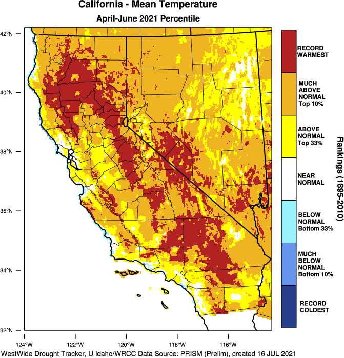
With the major exception of the immediate coast (which, as previously discussed, has been blessed with a persistent marine layer along with cool temperatures and even occasional drizzle), most of California has experienced a long period of relentless heat in recent weeks and months. June was the hottest such month on record across most of the CA interior, and the April-June period was the hottest on record across most of the Sierra Nevada and foothills ringing the Central Valley. Finally, though, even inland areas are getting a bit of a break at the moment–long and record-breaking stretches of triple digit heat have ended across the Central Valley, and the mountains are slowly cooling. (It’s so dry, in fact, that it’s actually getting pretty chilly at night in some places due to efficient radiational cooling.) Today is one of the first days in…I can’t even remember how long, but at least a couple of weeks…when there is no record breaking heat anywhere in the state.
The bad news: a dry lightning event is looking increasingly likely on Sun/Mon
If you sensed that there was a big “but” coming…you’d be correct. Unfortunately, one of the very things I was really hoping wouldn’t happen this summer, in the midst of our extreme to unprecedented drought, may now be coming to pass: the *potential* for a substantial and relatively widespread dry lightning event across central and northern California from Sunday into Monday. Unlike the massive August 2020 lightning event–which brought over 10,000 cloud to ground strikes to Northern California–this event does not involve any remnant moisture from East Pacific tropical cyclones. Instead, this event is taking a more “traditional” path: monsoonal moisture and elevated atmospheric instability will move over California from the southeast, bringing a chance of thunderstorms first to the mountains and deserts of southern California on Sunday and then spreading northwestward across central and perhaps northern California overnight Sunday into Monday.
Storms over the SoCal mountains and deserts will likely have some precipitation associated with them due to the deeper atmospheric moisture there. Dry strikes are still possible down south, but most lightning south of Santa Barbara will be associated with some rainfall that will partly offset fire risk. A few storms could also make it west of the mountains in SoCal, and there’s a slight chance they could affect the LA or San Diego areas.
Farther to the north, though, the risk of dry lightning is considerably higher. The models are currently indicating a pretty significant amount of elevated instability (CAPE over 250J/kg in some spots away from the mountains, which is quite respectable for California in summer), along with both mid-level moisture and a clear atmospheric triggering mechanism (a modest easterly wave/vort max combo). Thus, the pre-conditions will likely be set–and there will be a plausible trigger to potentially release that latent instability over NorCal. While there will actually be a decent amount of moisture in the atmospheric column, the lower layers of the atmosphere will be quite dry. While brief showers could occur with any storms across central or northern California, most strikes will likely occur away from these very isolated rain cores and even these brief showers might not be enough to tamp down lightning ignitions amid extreme drought conditions.
Fire Weather Watches have been issued for a majority of northern and central CA for this event. While I don’t expect all areas covered by these watches to experience dry lightning, I *do* expect it will occur over some portion (perhaps a substantial portion) of this broad watch area. The highest likelihood of lightning will be across the Sierra Nevada and the foothills ringing the Central Valley (north, east, west, and south)–but it could occur virtually anywhere, even across the coastal Bay Area. I do think the northwestern quarter of CA (the North Coast, and probably also Mendocino County) will most likely escape this event–but the spatial details with these kinds of set-ups are always a little fuzzy so it would be wise to pay attention to the forecasts heading into the weekend.
What are the wildfire risks? How might this event compare to Aug 2020?
It is worth emphasizing, for the sake of folks (legitimately) traumatized by the extraordinary events of August 2020 in northern California, that neither I nor the NWS thinks it’s likely we’ll see a repeat of that extreme dry lightning event. Then, over 10,000 cloud to ground strikes occurred over a <12 hour period–igniting hundreds of fires, some of which burned for months. The broader good news: I doubt we’ll see nearly as much lightning from this event. The more localized good news: recent fog and drizzle along the immediate coast will keep fire risk in marine-influenced areas much lower than it was leading up to the August 2020 event.
The bad news: even a couple hundred dry lightning strikes (10-100x fewer than the Aug 2020 event) could lead to big problems, for several reasons. First: away from the immediate coast, vegetation flammability remains at *record* high levels for the calendar date due to the extreme drought and recent record heat–much drier than last year at this time, and well above even typical Aug or Sep peak levels in some areas. Second, there is already a great deal of large wildfire activity across NorCal and the broader West (plus Canada)–meaning that firefighting resources are heavily drawn down and it will be difficult to allocate new resources if there are numerous new fire ignitions this weekend. For this reason, I remain pretty concerned regarding the potential of this event to ignite at least a handful, and perhaps dozens, of new fires somewhere in CA–particularly in the Sierra Nevada and Central Valley foothill regions (though possibly elsewhere as well).
Could this event be a “bust?” Yes, it certainly could–dry lightning outbreaks are notoriously difficult to predict. And I personally hope this one falls apart, since California certainly does not need dozens of new wildfire ignitions in remote areas right now! But if you are in/near the foothills or Sierra especially, I would take this potential event seriously until the risk has passed (likely by Monday night).
Read the rest of the .
