

By Robert Bernstein
Believe it or not, Monday was the first time I ventured to the area of destruction in Montecito. A friend was visiting from San Francisco and she wanted to go hiking there and see what had happened.
Here are all my photos from our little outing.
We first tried to go to the Cold Spring trailhead. But there were Road Closed signs in both directions on that area of Mountain Drive.
Then we went to the Hot Springs trailhead and had a similar experience. We did find a possible way in. But there seemed to be no place to park anywhere nearby. It was very frustrating as the trails supposedly are open now. But apparently the City and the County are blocking access to get to these trails.
Then we tried San Ysidro Trail. Success! That trailhead is open and there is parking on Mountain Drive.

It was sad to see the destruction near the trailhead. We explored there a bit before heading up the trail. Some construction was underway

But mostly that area was still a scene damaged homes and debris


The central area of San Ysidro Ranch seems to have survived

But the lower area seems totally destroyed

That gully behind me used to be the bridge on Mountain Drive that led to San Ysdiro Ranch from the east

We then started up the San Ysidro Trail which seemed normal in some places near the start

We saw this beautiful view through the fence on the east side as a homeowner replants

But on the west side toward San Ysidro Creek we were looking into a destroyed home

On the west side of San Ysidro Creek we could see cabins under construction at San Ysidro Ranch.


Continuing to walk up the road we saw a gate on the east side that seemed untouched

But on the San Ysidro Creek side, more scenes of destruction


We came to the junction with the Old Pueblo Trail. That area seemed OK

But as we came over that crest and looked up the San Ysidro Trail it was clear how much the Creek had been widened. And the trees and other vegetation were damaged or swept away.


We saw a family visiting from Denmark who said they were coming back down from the dry San Ysidro Falls. They said it was passable.

It was quite hot, so we decided not to head up that way, trusting the report of that family. Instead, I scouted to find the lower part of the McMenemy Trail. That trail used to connect from the San Ysidro Trail all the way over to the Hot Springs Trail. It also connects to the Girard Trail and to the Saddlerock Trail. I did not scout all the way to any of those trails. But I did get far enough to be satisfied the McMenemy Trail is passable once you get away from San Ysidro Creek.
Here was the challenge near the San Ysidro Creek. You have to climb down into the rocky creek bed


But on the west side of the Creek the trail was in fairly good condition


I then headed back to the San Ysidro Trail a different way, crossing further downstream

These flowers are notable for appearing after a fire or other disaster


I scrambled up the east bank of the Creek to get back out

It is passable now as long as there is little water in the Creek

After our short hike, we headed back out on East Valley Road where we were met with more scenes of destruction. East Valley Road is on the left in this photo, lined by utility poles

One destroyed house was near the road, with another further back behind it


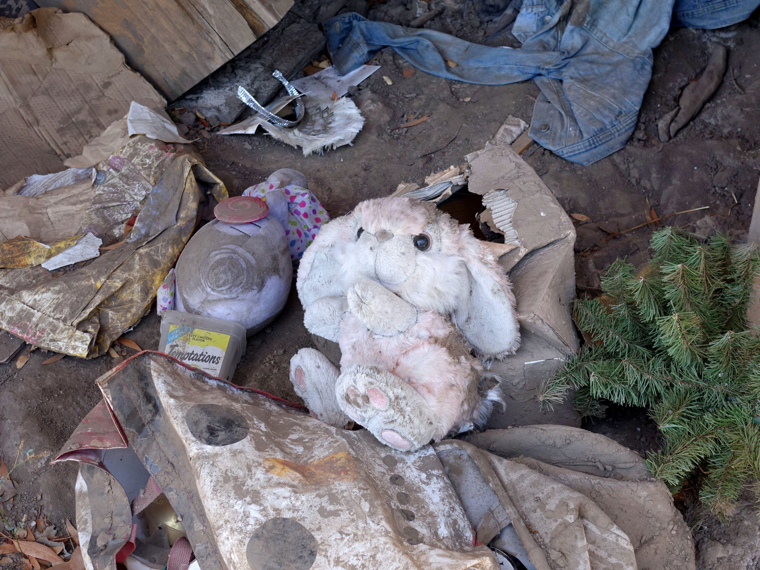
The scene in the nearer house was eerily frozen in time with this stuffed animal and a saved newspaper in one room

But it is clear the area is coming back, with construction underway!


[Editor’s Note: Author and photographer Robert Bernstein along with edhat’s editor have agreed to remove the photos showing the partial interior of homes damaged during the 1/9 debris flow]


None of these photos is illegal or invasive.
RED, the best front country trails start in Montecito. Period.
It is not a disaster exclusion zone. Some of these comments are rather menacing. Much more of a threat than any photos. Maybe people can lighten up a bit and appreciate being able to see what happened in our community.
Disaster Exclusion Zone signs everywhere? Really? You have no idea what you are talking about. If you don’t like looking at the photos, don’t look at them. Judging by the large number of hits, a lot of people are quietly looking at them.
Isn’t venturing into homes with out permission and onto private property considered trespassing and an invasion of privacy? Especially while taking photos for your own personal pleasure?
Thank you, Robert, for the pics.
Squeamish to post those interior home views. Please take them down.
Publishing the photos on Edhat goes beyond “personal pleasure.”
This is very inappropriate and distasteful. What are you trying to encourage or share here? Edhat please remove this!
I would be horrified if the interior of my home was posted without permission.
I’ve seen a lot of newspaper photos of the inside of destroyed homes. Also, on TV coverage. What makes it such a big deal here?